newzealandinspiration
vakantio.de/newzealandinspiration
Chapter 25 - The Tongariro Hike of Our Lives
Pubblicato: 12.08.2020


The Tongariro Alpine Crossing is the most popular hiking trail in New Zealand. To hike it, we checked into a campsite in National Park Village. The village had nothing much to offer, except for a gas station and a mountain view. We had to spend three days there because the shuttles only operate in good weather, and unfortunately it was raining non-stop for us. It was also colder than ever. I had to take out my winter jacket, which I had packed away in November, and I was still freezing. At the same time, there was a Polish middle-aged couple camping in the National Park Village. They were occupying the living room all the time and making one free black tea after another. They lived in Switzerland, quit their jobs, and were now traveling, I believe mainly to socialize with people there.
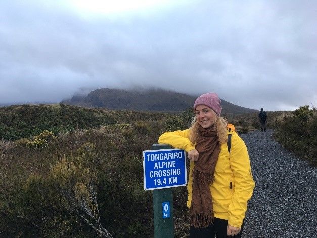
The night before the Tongariro, it cooled down to 5°. It was probably just as cold in our car. We slept with thick socks, leggings, sweaters, and scarves, and Celina slept with her head under the duvet. I hardly slept at all. A great foundation for hiking 20 kilometers the next day! When the alarm went off at 5 am, I sprinted to the bathroom wearing my winter jacket. At 6 am, we, along with 10 other people, were picked up by a shuttle bus at a nearby parking lot. We booked the earliest shuttle because we assumed we would be very slow. (When we told the Poles about it, they groaned in shock). The motivated bus driver told us that today, due to strong winds, we could only hike half of the trail. Therefore, we could "only" go to the Emerald Lakes and back. In the shuttle, we sat next to two guys whom we had seen at Wai-O-Tapu, and we were glad that we didn't have to drive the trail with our car. Even for New Zealand standards, this road was bad and shook us vigorously. Upon arriving at the parking lot, we enthusiastically took a few photos of the 19.4 kilometer sign and calmly set off.
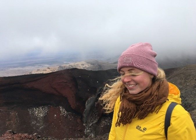
The weather was now pleasantly cool, just a bit gloomy. The trail was completely fine, it went on a level footpath between the mountains, and we hiked in a relaxed manner.
There were several warning signs that pointed out various things to us, but mostly whether we were really fit enough. One sign had two photos: one showing the path ahead of us in the sun, and the other showing the same path enveloped in clouds. Exactly how it looked like for us at that moment. It said that in these weather conditions, it would be better to turn back. However, we were constantly being overtaken by other hikers who greeted us friendly with a "Hi", so we continued. After about an hour, we had to climb stairs every few meters and walked on a wooden boardwalk that crossed a swamp. We passed the last toilets for a while (where there was a statistic hanging, showing how many people have to be rescued from Tongariro each year, very motivating). Then it went very steeply uphill with many stairs. At this point, we had already been hiking for almost three hours and had stopped several times. (It should be noted that Celina and I are anything but experienced hikers). When we had breakfast halfway up the stairs, the view downwards was very poor because a cloud suddenly hung in the mountains, and it became so foggy that we could only see the path and white mist. But that was definitely cool as well, and we were not bothered by it at first.
From the testimonials I had read in advance, we knew that the worst part was supposed to be a so-called Devil's Staircase. We walked about a kilometer through a big crater, pushed by a strong tailwind. We thought three sections were the Devil's Staircase ("I think this is it now"), until we finally arrived at it. Before that, we were warned by a motivating sign about the now most difficult part and again asked, "Are you fit enough?" Although we had already been stopping quite a lot before, we optimistically started the sandy, very steep ascent between rubble and rocks. That was definitely the worst part. It was basically a climbing tour and already tough for unexperienced hikers like us in fine weather, but the cold and the terribly strong, icy wind sweeping over us freely, finished us off. Celina and I developed our own strategies to get through this part. Celina had to fight her way forward like an old retiree, while I sprinted a few meters until I crouched behind a rock to catch my breath. I was annoyed because in the morning I had taken mine or Celina's scarf back to the car when I saw how thinly dressed the others were. We started trembling really hard, and the worst part was that we couldn't breathe while walking due to the wind. Also, we still only saw fog, and now we also encountered fewer and fewer other hikers. After ages - we probably only managed to cover 100 meters - we crouched behind a pretty big rock that shielded most of the wind. There, we crouched helplessly for a while. We were completely exhausted and frozen. The hair sticking out of our hats was wet and frozen, there was frost on my eyelashes, and our eyes were burning red. Our fingers were about to die, so I took out grandma's thick socks that I had somehow packed in the backpack as a safety precaution, and we could wrap them around our hands. (Later, a hiker passed us, proudly showing us her hands, which were also wrapped in wool socks).
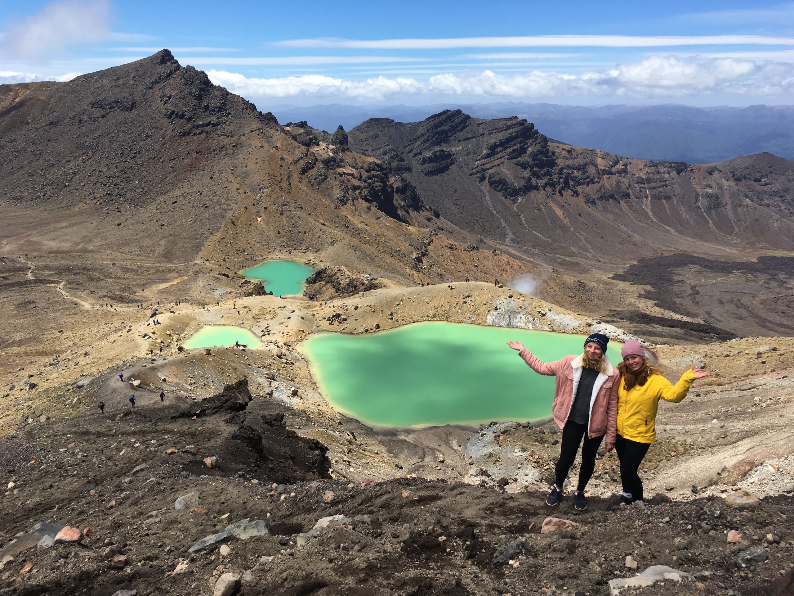
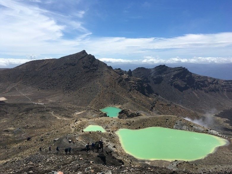
We persuaded ourselves to continue climbing higher. Because in some way, we hoped that we would eventually be literally over the mountain, where hopefully we would be protected from the terrible wind. We needed more rocks for shelter, and the last stretch, Celina crawled up in sync with a severely worn out retiree, while I fought for my oxygen. We couldn't see at all what was around us, but the path became narrower and narrower. We knew that it must go steeply down on both sides. Then, finally, we reached the highest point and immediately dropped a few meters lower in the sand. It was still just as foggy, but at least sheltered from the wind. First, we restored ourselves, then we took a lunch break, and incredibly, the cloud cleared for a moment, revealing a view down to the Emerald Lakes, the green volcanic lakes. It looked really incredible!
The longer we waited, the more often we could admire the view, until the clouds finally completely disappeared, and we could even get a glimpse of the surrounding landscape. Together with the other hikers, we slid down the loose rubble path to the lakes, with someone having to catch us twice to protect us from falling. (Each of us fell once that day). We spent more than an hour at the lake, enjoying the view, asking many people to take photos of us, and taking our own photos.
It was so beautiful and sunny there that we almost forgot what awaited us on the other side of the mountain on the way back. It was a bit daunting to see the very steep path in front of us.
With a heavy heart, we bid farewell to the amazing lakes and climbed up in small steps. It was so slippery and steep that we had to hold on to the ground to make progress. When we reached the top, the fit hikers had to take another break. This time, however, with a view of the red crater that had been obscured by the fog earlier. We also discovered that on the way there, we had walked on a very narrow sandy path between the craters and stayed there for a while to enjoy the view.
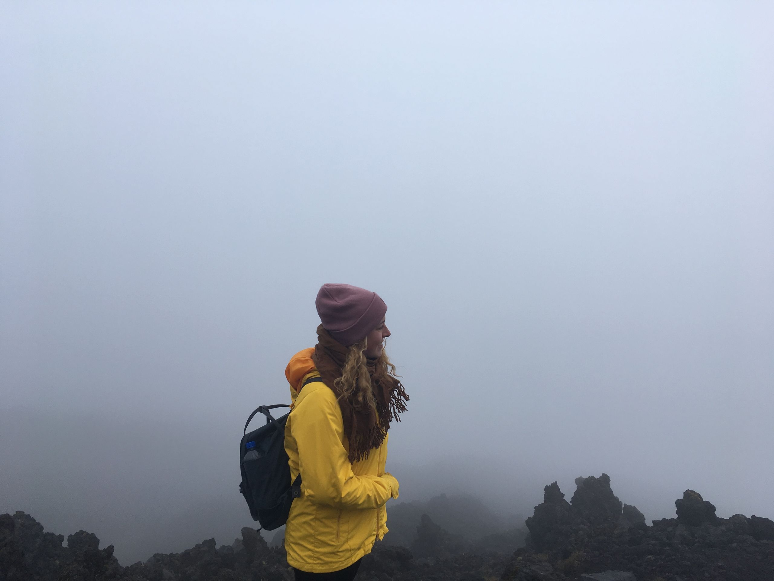
On the way back, it was still quite windy, but not as freezing cold anymore. We were still amazed by the views that we could not see before.
When the parking lot came back into sight after three hours, we realized that we had frostbitten hands. The weather signs at the parking lot showed temperatures below freezing and wind speeds of 80 km/h on the mountain.
Completely exhausted, we collapsed on the nearest bench, where the two guys from the bus were already waiting and doing stretching exercises. They were the complete opposite of us. Because while we probably looked as if we had experienced several near-death experiences throughout the day, the guys were in a really good mood and fit. They organized the shuttle back (in the meantime, Celina's legs had started to tremble noticeably), and the bus driver from the morning picked us up again. He high-fived us and asked us about our day. That's when it turned out that the guys had hiked the entire Tongariro to the other side and back. In short, they covered twice the distance as us, but in the same amount of time.
11 hours after the shuttle picked us up from the village, we were back at our accommodation. I think the Poles (who had done a 4-hour hike to mountain lakes instead of Tongariro) didn't quite believe that we had just completed the hike of our lives today. When I went to the bathroom to shower in the evening and looked in the mirror, I also knew why. I looked exactly how I felt: My eyes were bloodshot, and otherwise I looked like a corpse. With the firm belief that both of us would definitely get sick, we cuddled up in the duvet in the evening, but still felt cold.
Flori later always got annoyed that we either referred to our previous time in New Zealand as the Te Puke Holiday Park or as "that mountain". And that's true. Even if neither of us would ever do such a hike again without training, Tongariro was the highlight of our entire time in New Zealand.
Risposta