Info section 12: Travel- Places on the South Island Part 2
Հրատարակվել է: 10.08.2020
Arthur's Pass:
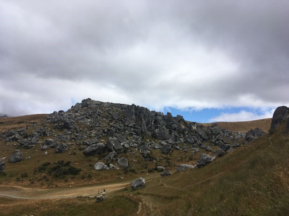
The most popular car route from the West Coast to the East Coast or vice versa is Arthur's Pass. It is well known that New Zealand's landscape can change within a few kilometers, but nowhere else can you see the diverse and incredibly beautiful landscape of the country in all its glory like in Arthur's Pass. The drive takes about 3 ½ hours and can be done either from Greymouth on the west side or from Christchurch on the east side. During the drive, you will pass many rivers, lakes, and various mountain passes. As you move further west, the otherwise dry landscape becomes increasingly replaced by rainforests. halfway through the route, you should definitely stop at Castle Hill. There, you can take a walk among the rocks and stones on the hills, have a picnic, and simply enjoy the scenery!
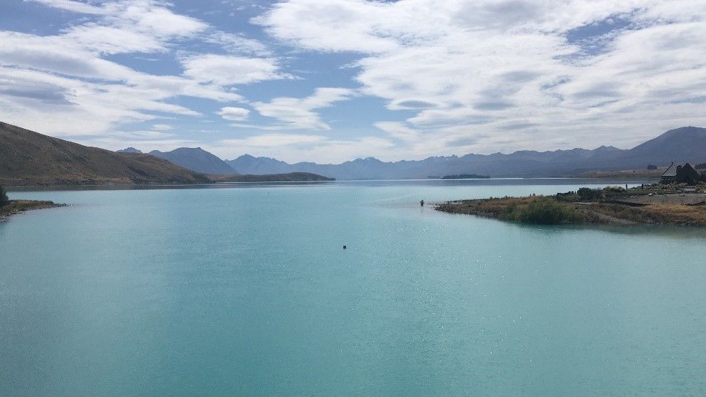
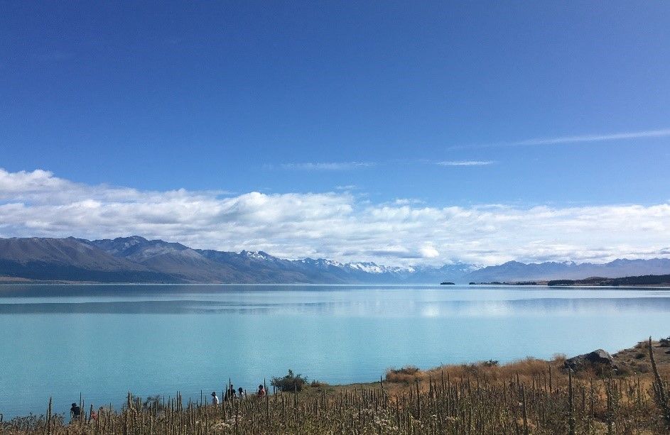
Lake Pukaki & Lake Tekapo
Lake Tekapo and Lake Pukaki are two of the three lakes that are especially popular because of their turquoise water. They are centrally located on the South Island, close to each other, and offer a beautiful panoramic view from any side. The lakes owe their intense color to glacier particles that dissolve in glacial water and flow into the lakes. For particularly idyllic photos of Lake Tekapo, we recommend taking a walk to the "Church of the Good Shepherd" via the Lake Tekapo Footbridge. Although Lake Tekapo is more popular among tourists, we found that Lake Pukaki was just as impressive. From there, you also have a great view of Mount Cook and the mountain range in the background. Truly unforgettable!
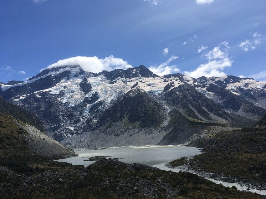
Mount Cook
Mount Cook, also known as Aoraki, is the highest peak in New Zealand, reaching 3724 meters. The best way to reach it is from Twizel or Tekapo, via the Mount Cook Road along Lake Pukaki. Mount Cook Village is the starting point for many hikes. The most popular and easiest hike is the 5-kilometer long Hooker Valley Track. This takes about 3 hours, crosses three suspension bridges, and offers views of Mueller Lake, the surrounding mountains and peaks, and finally Mount Cook. There are also hiking routes to Mount Cook, but these are only suitable for experienced mountaineers and are still very dangerous.
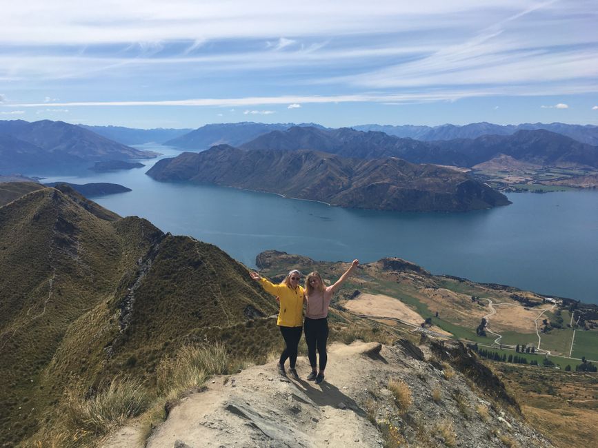
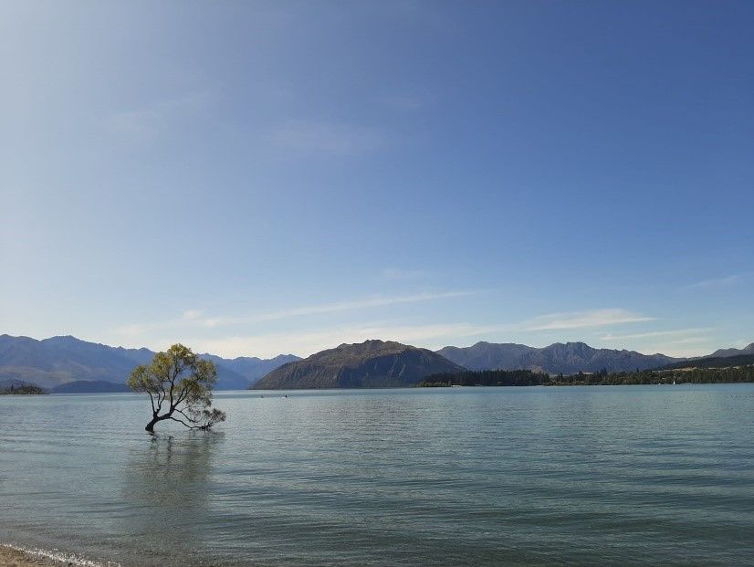
Lake Wanaka
Another incredibly beautiful lake on the South Island is Lake Wanaka. In the town of the same name, you will also find the most photographed tree in the world, the Wanaka Tree. Actually, we couldn't quite understand the hype about it. At sunset, about 30 professional or hobby photographers squeezed onto a small spot on the beach just to get a photo of it. With good lighting conditions, the small tree in the water does look pretty cool, especially with the backdrop of Wanaka's landscape.
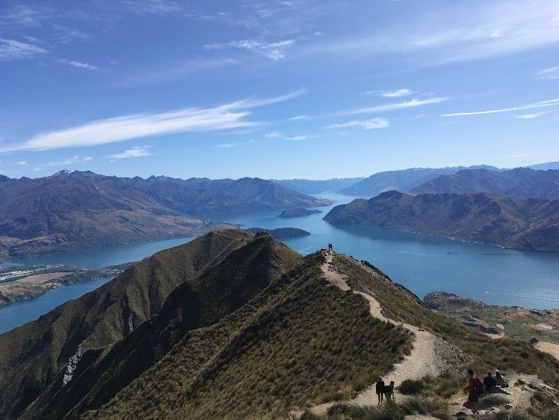
Roy's Peak
If you find yourself at Lake Wanaka, you should definitely take the Roy's Peak Track to the south. Although the ascent on the permanent gravel path is not too difficult, it is still very strenuous and should not be taken lightly. The entire 8-kilometer route to Roy's Peak is uphill all the way. Especially under Wanaka's sun, it can get very hot in summer. Therefore, it's worth starting the hike before or during sunrise. As inexperienced hikers, you should allow around 6 hours for this 16-kilometer hike.
Don't be surprised if you encounter joggers coming down during the ascent: the 8-kilometer descent is also quite strenuous on the calves!
But as with almost every hike, those who reach the summit know what they have done it for. In the case of Roy's Peak, you will be rewarded with a panoramic view of Wanaka's picturesque landscape. We were quite proud when we finally managed to take a photo that qualifies as a famous Roy's Peak picture. Can you do it too?
Tip: Sufficient water and provisions should definitely be on an appropriate packing list. The only two toilets are located a few meters above the parking lot at the bottom and then at the very top of Roy's Peak.
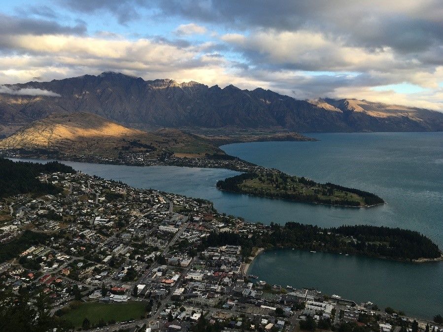
Queenstown
Queenstown is the ultimate adventure city. Whether it's skydiving, bungee jumping, paragliding, jet boating, mountain biking, or skiing and snowboarding in winter, all of this is possible there and even more. The lively city is located on the banks of the beautiful Lake Wakatipu and is completely surrounded by mountains. Queenstown is not very big, so it's worth considering early on where and how many nights you want to stay. Campsites and hostels are quickly fully booked (especially campsites need to be pre-booked!). A cable car ride to Bob's Peak (for $44 per person) with a breathtaking view of Queenstown and the surrounding area is highly recommended.
Te Anau
Lake Te Anau is the largest lake on the South Island and attracts tourists not only because of its beautiful surroundings but also because of the small town of the same name on its shores. Since Te Anau is located at the border of the Fiordland National Park, it is almost impossible to miss. Most scenic flights over Milford Sound also depart from there.
A tour in Te Anau that we can definitely recommend is the one to the Glowworm Caves. At $103 per person, it is quite expensive, but it is definitely worth it. The highlight of the 2-hour tour is, as the name suggests, deep inside a cave on the other side of Lake Te Anau. In a group of 12 people, we were guided by a guide to an underground lake. There, we were guided into a small boat and slowly maneuvered through the narrow cave. It was so dark that we couldn't see our own hand in front of our eyes, and nobody spoke. Throughout the entire time, all we could see were thousands of glowworms above and around us. It was simply unforgettable for all of us!
Milford Sound
Since the road to Milford Sound was closed due to floods, we had to skip this national park. Therefore, we can only report what we have heard: It is said to be the most beautiful national park in New Zealand and one of the most breathtaking places in the world (what a pity!). You can explore the Fiordland National Park either by scenic flights or boat trips, which are best booked in advance as there is quite a rush, especially in high season. (There is also a pretty extreme hiking trail). There, you can see rainforests, several waterfalls, turquoise water, and, if you're lucky, even dolphins!
The Catlins
A very special region in the southeast of the South Island is the Catlins. This relatively uninhabited area is actually still a secret tip, and not many tourists find their way there. When driving along the coast, you can occasionally spot penguins, sea lions, or dolphins. Due to COVID-19 and the chaotic end of our stay in New Zealand, it was no longer possible for us to see the Catlins. If we were to travel to New Zealand again in our lifetime, this would be our first stop. Here are the places we would have loved to visit:
Nugget Point Lighthouse
A really cool photo spot in the Catlins is the white lighthouse at Nugget Point. From there, you have a great view of the sea and the protruding rocks. You can also observe seals there.
Cathedral Caves
There are huge naturally formed caves along the coast at the Cathedral Caves, which can be reached after a walk along a very pretty beach. Admission costs 5 NZD. Be sure to check the tides: the Cathedral Caves can only be visited at low tide.
Curio Bay
This attraction in the Catlins can also only be visited at low tide. In this bay, there is a petrified forest and penguins to see. The nearby Porpoise Bay is also said to be worth a visit. There, you can also observe yellow-eyed penguins or sometimes even dolphins.
Waterfalls
The Catlins are not only the right destination for animal lovers, but also for waterfall enthusiasts. The 22-meter-high McLean Falls, the three-tiered Purakaunui Falls, or the less well-known Mattai Falls are said to be really beautiful.
Slope Point
A sign on the rocky headland where Slope Point is located marks the southernmost point of the South Island... What a feeling it must be to stand on the edge of the world?
-> #13 Everything about camping sites follows
Պատասխանել