26/08/2018 - Tongariro National Park
Publicado: 24.09.2018


Subscríbete ao Newsletter
After just one night, we left the small town "National Park Village". Even though the community, which possibly received the most uncreative name in all of New Zealand, does not offer any cultural attractions, we must highlight its perfect location. It specializes exclusively in tourists and is centrally located in the "Tongariro National Park" - the oldest of all New Zealand's national parks.
The weather was as hoped (more than) good - the longer wait last week is already paying off. The prominent landmarks of the region were visible even before breakfast.
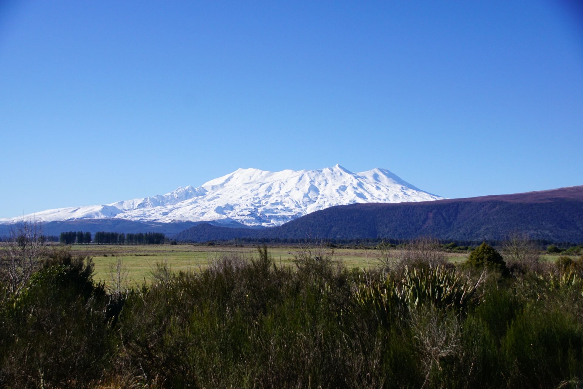
"Mount Ngauruhoe", similar to "Mount Taranaki" on the west coast, is a perfectly shaped volcano, as seen in picture books. The same opinion seemed to have been shared by director Sir Peter Jackson, who chose the 2,287m high mountain as a filming location for the "Lord of the Rings" trilogy. This is where Frodo and Sam's long and arduous journey ended, as they destroyed the ring in Mount Doom.
However, Mt Ngauruhoe has not existed for very long. It is the youngest volcano on the North Island and erupted every nine years until 1975! In close proximity is the namesake of the national park: "Mount Tongariro". Also a volcano with a height of 1,976m, its last major eruption occurred six years ago.
The third and final volcano in the group is also the highest at 2,797m. "Mount Ruapehu" is an unpredictable volcano that has caused destruction several times. For example, on Christmas Eve in 1953, the rim of the crater lake collapsed, releasing a large wave of volcanic mud. This buried a railway bridge and a train that couldn't brake in time and plunged into the abyss. Over 150 people lost their lives in the tragedy.
But we were not intimidated by all the facts and headed straight for the volcanic landscape. Naturally, there were some photo opportunities on the side of the road. For example, we took a great picture of a warning sign about roaming kiwis together with Mt Ngauruhoe. :)
After about 30 minutes, we approached the mountain village "Whakapapa". Without any warning, we found ourselves in a traffic jam! The main road (and almost the only road in this town) was crowded with cars and winter sports enthusiasts. Several buses transported skiers and snowboarders to the nearby ski area.
Fortunately, we found a parking space right in the city center - and didn't have to walk along the country road for 15 minutes or more, with cars speeding by at high speeds.
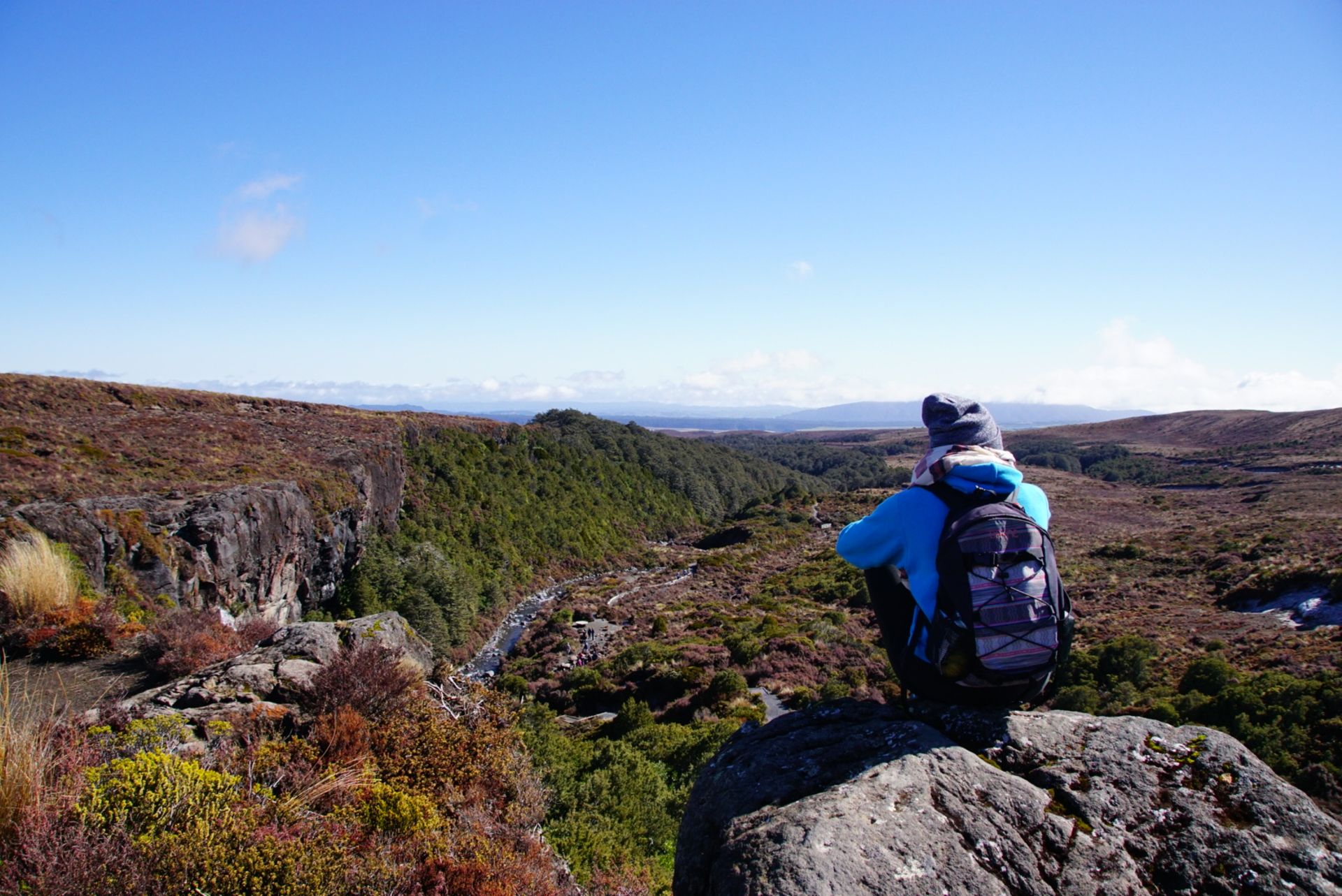
In the chaotic Sunday hustle and bustle, we got an overview and were soon on a hiking trail. The two-hour circular walk to the "Taranaki Falls" began by crossing flat steppe, allowing us to always have the three volcanoes in sight. We then hiked through a densely forested area along a stream. After 50 minutes, the 20m high waterfall suddenly appeared out of nowhere. The Taranaki Falls found its way into the valley through a crack in the rock face. An impressive sight that catapulted it into our personal ranking of the 15 most beautiful waterfalls in New Zealand.
From the catchment area of the waterfall, we continued to its highest point. We followed the circular path and soon found ourselves on the cliff that we had just viewed from below. From here, there was a panoramic view of the plain - even Mt Taranaki could be seen from a distance of 250km!
Now we had to make a difficult decision. Do we stick to the two-hour circular walk and return to Whakapapa, or is our motivation strong enough to march to another attraction? We had our eye on the 7km long track to the "Tama Lakes". The travel time was given as an additional 90 minutes for the one-way trip. This meant: we would be on the road for at least the next four hours...
We wanted to give it a try. The weather was simply too good today. So, at around 11:45 am, we turned off at the signpost in question and had only one goal in mind: the Tama Lakes. Due to the (largely) flat area, we were able to occasionally guess the further course of the path. But an end to the journey was not in sight for a long time. After about 40 minutes, doubts arose. The Mount Doom, which was constantly in our field of vision, was now surrounded by a blanket of clouds. In addition, the sun disappeared behind clouds, making the outdoor temperature even less pleasant at an altitude of over 1,200m.
After another 20 minutes, a glimmer of hope appeared. A sign indicated that the remaining distance to the lakes was less than 30 minutes. From this point on, there was only one direction: forward!
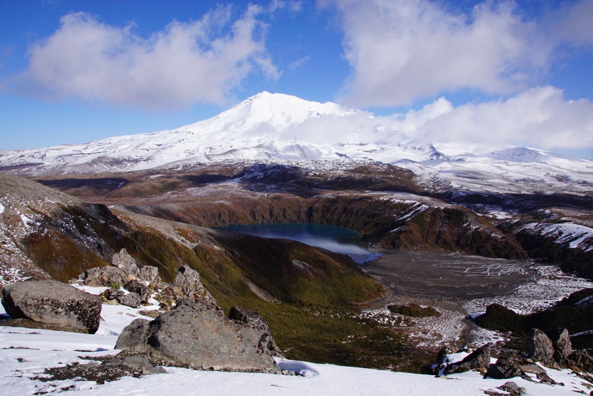
We quickly crossed one or two streams and after more than 2.5 hours (including the half-circular walk to the Taranaki Falls), we reached the lower Tama Lake. We arrived at the viewpoint, took a big sip of water, and stared speechless at the scene that unfolded before us. Where active volcanic craters raged over 10,000 years ago, a freshwater lake has formed today. The light blue lake, framed by overgrown mountain slopes and the many thin rivers that flow into it - unbelievable. We tried to capture the dimensions with photos and videos, but it is difficult to fully grasp.
Since the effort to get here was quite exhausting, we enthusiastically followed the remaining hiking trail. The further we walked, the more wintry the surroundings became. The trail was partially icy, occasionally ankle-deep in snow, and the signposts were not always immediately visible. Luckily, we were able to maintain visual contact with another couple who were walking just a few meters ahead of us and were also looking for the right path. ;)
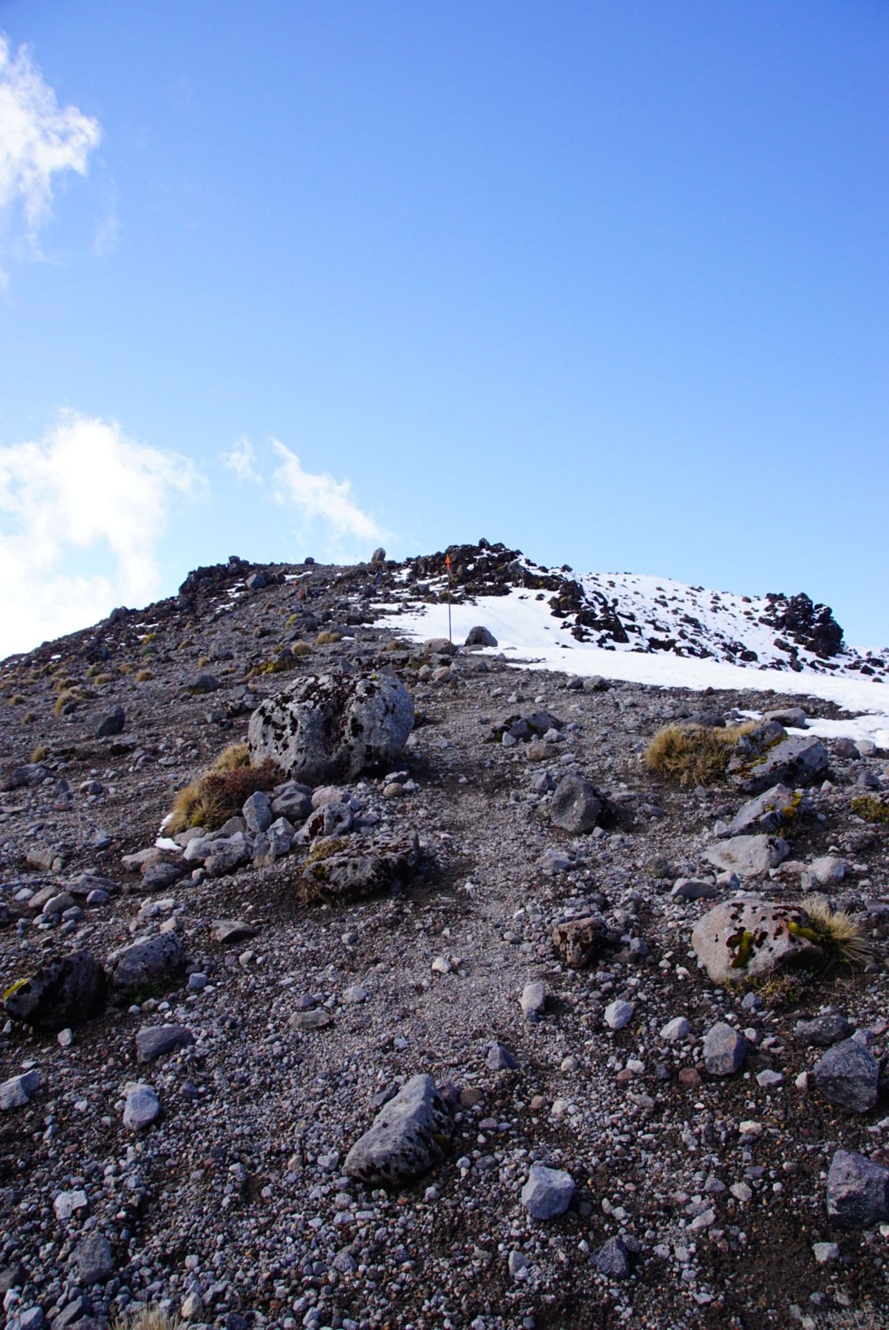
After about 20 minutes, the most challenging section of the hike appeared in front of us. The route led over a steep mountainside consisting entirely of loose stones. Apart from the steepness, it was primarily the risk of slipping that we had to watch out for! We slowed down, took one step after another, and climbed the passage without incident. On the last few meters, more and more snow joined us, our thighs began to burn, and the mood threatened to sour. Just at that moment, a backpacker came towards us, giving us encouragement: "It's absolutely worth it!". So, let's go now, we're almost there.
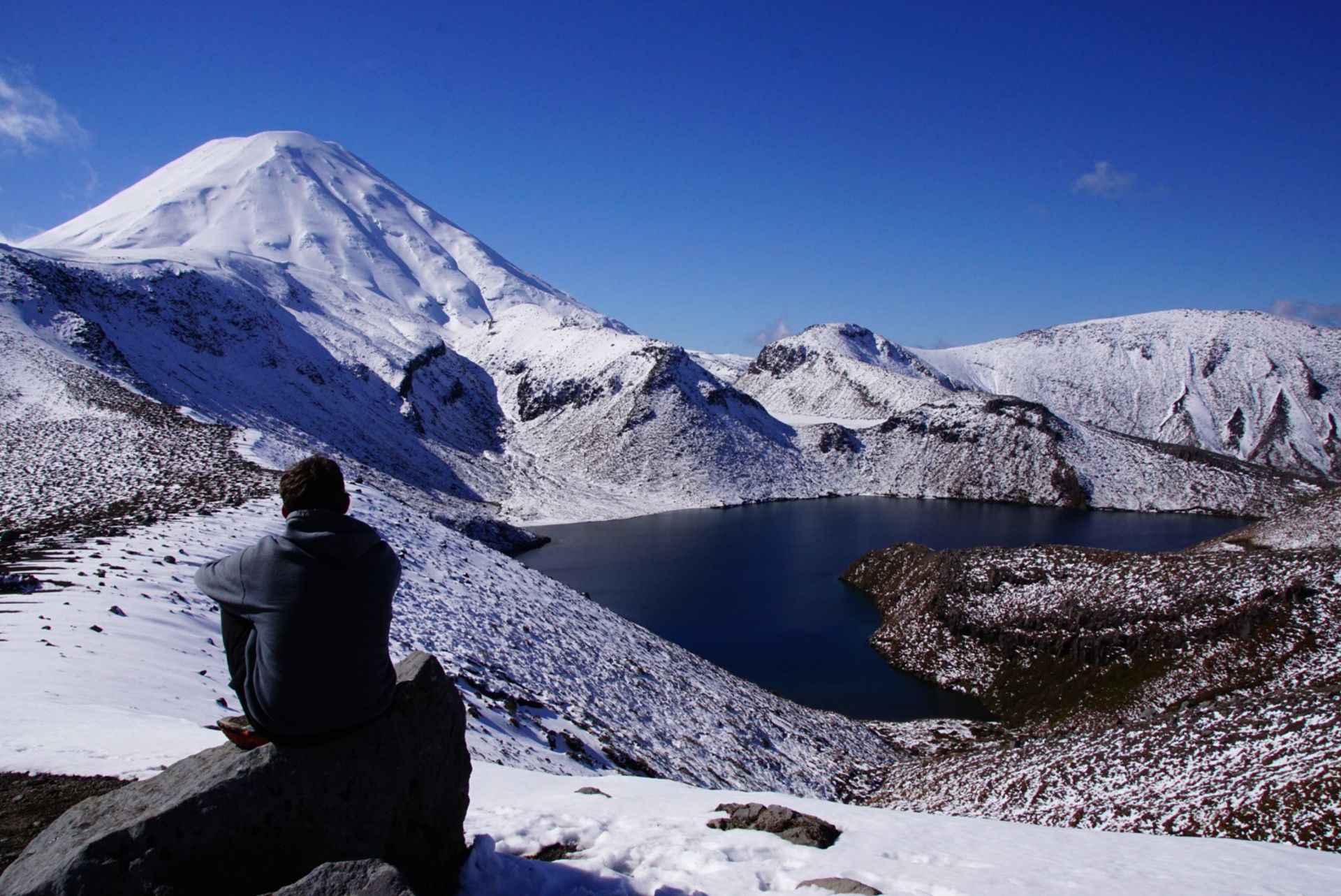
Minutes later, we arrived at the rocky plateau. The 360° panorama that now surrounded us cannot be described in words... Exhausted, we sat down on a larger rock and enjoyed the incredible view from the "Upper Tama Lake Lookout" along with a handful of other hikers of all ages, basking in the warm sunshine. - We had high expectations for the day, after all, we had been waiting for it for a long time. But the images from up here compensated for everything - the waiting and the effort to get up here! - The view of the deep blue lake, Mt Ngauruhoe, and the white winter landscape was phenomenal. The view of the other side was fantastic as well. The wide Mt Ruapehu with its snow-covered slopes was clearly visible. As was the Lower Tama Lake. Fantastic. Simply breathtaking!
After taking countless pictures, we enjoyed our apple slice and would have liked to stay forever.
At around 2:10 pm, with heavy hearts, we set off on the return journey. The advantage here were the distinctive points that gave us an idea of how far we still had to go. Nevertheless, we cannot deny it - the way back to Whakapapa seemed endless despite fewer breaks.
At some point, the first houses appeared on the horizon - and after a total of six hours, we returned to the car, relieved, exhausted, and overjoyed! We covered a total distance of over 17 kilometers. It's amazing to see what we little hobbits are capable of. ;) As a reward, we had a piece of chocolate of a special kind. A New Zealand one filled with peanut butter. Yummy!
By now, it was 4:10 pm and we had not yet found a place to sleep for the night. We tried our luck at the local campground in Whakapapa. Initially, the receptionist did not give us much hope. However, when he learned that we were only sleeping in a car and not driving a large camper, he finally found a parking space for us. We were allowed to park on the narrow roadside and use the facilities.
Although our Sam was quite steeply inclined, who cares after such a day?
Subscríbete ao Newsletter
Resposta

Informes de viaxes Nova Zelandia