
Twelfth day
Foilsithe: 22.06.2017


Liostáil le Nuachtlitir
Hollup - Brønnøysund
111km
Average speed of 20,6km/h
Initially cloudy with sunny intervals throughout the day, now not a cloud in the sky
Strong headwind, but if Jonathan does the windbreaker, you don't notice it as much ;)
Originally, the three of us planned to ride alone at our own pace today, but then we decided to ride together until the ferry (20km). The landscape was magnificent. Although it rained heavily at 4 o'clock, by half past eight it looked gray but there were already gaps in the clouds, and it was supposed to be nice today. The morning atmosphere was definitely magical. Where the sun came through, the water glistened, the two high mountains (770 and 1050m) on the other side of the fjord were covered in clouds and only revealed their peaks for a few moments. There was still little wind and with fit Jonathan as a pacemaker and wind blocker, Franz and I were pulled along at a brisk pace. The first 20 km were simply great. We rode up a small pass (more like a gentle climb) or around a curve and suddenly a different view opened up. Always surrounded by dark gray, steep mountain ridges, the road mostly led us to sea level into a small fjord and out again or around a bay. The perspectives constantly changed and we stopped again and again to take photos. We had aimed for the 10 o'clock ferry from Holm to Vennesund, but I was not stressed and didn't really care if we would make it or be an hour later. 5 minutes before 10 o'clock we arrived at the harbor, boarded the ship, and off we went. The trip only lasted 20 minutes. After all, it was only to the other side of the fjord. In the harbor restaurant, we wanted to "celebrate" with a coffee and a pastry, but then we decided to continue riding together. Always in the order: Jonathan, me, Franz, who had heavier legs today. In Vik, we could either follow the 17 to Berg or take a road marked as a hiking trail on the map, to the left around the ridge. The decisive factor for the path was that we supposedly only had to climb 80 meters in altitude. The path turned out to be a stroke of luck. In the shadow of the granite massif to our right, the path led through meadows and forests, past flat, turquoise bays again and again. And everything was deserted. We wanted to stop at a signposted rest area, but it was crowded with at least 50 kids. It was a beautiful flat bay, and we stayed anyway. Apparently, there was a school outing here with several classes.
From Berg, we followed the 17 again until Brønnøysund. We had already seen the famous mountain Torghatten not far away for many kilometers, which supposedly has a 35m high hole in the middle. We saw the mountain, but not the hole. In Brønnøysund, Franz decided to stay at the campsite, Jonathan and I were still undecided, but we stored all our luggage in the cabin and the three of us set off on super fast bikes to Torghatten, 17km away. It wasn't on our route, and we had to go back to the campsite anyway. When we arrived there (we still hadn't seen the hole), there were several options. We could walk up to the hole for 20 minutes or hike all the way up the 257m high mountain. I wanted to do both, of course. So first up to the hole.
We had just locked up the bikes when an older couple from Thuringia spoke to us, and I was amazed at how few sentences it takes to make yourself extremely unsympathetic: Locking up the bikes is very important, they almost had their bikes stolen in Wendland, and initially one doesn't trust Norwegians, but times have changed. They were at the same campsite, actually wanted the cabin we had, and how much did we actually pay... Really nitpicky stereotype Germans. Later, Jonathan and I agreed that if we ever become like that, please shoot us.
At 110m altitude, we had a spectacular view. The mountain itself stood quite lonely, and in the middle, there was a 35m high and 160m long hole. At first, I couldn't explain how it was formed, later I checked Wikipedia. It was the sea erosion that washed out the hole before the mountain rose further due to post-glacial land uplift. Of course, I had my drone with me and flew it through the hole twice. We were just about to walk through it when I heard my drone again. Confused, I looked around and indeed, someone else was flying through the hole with a mavic pro (much more daring than me). At that moment, I was a bit embarrassed about my flight.
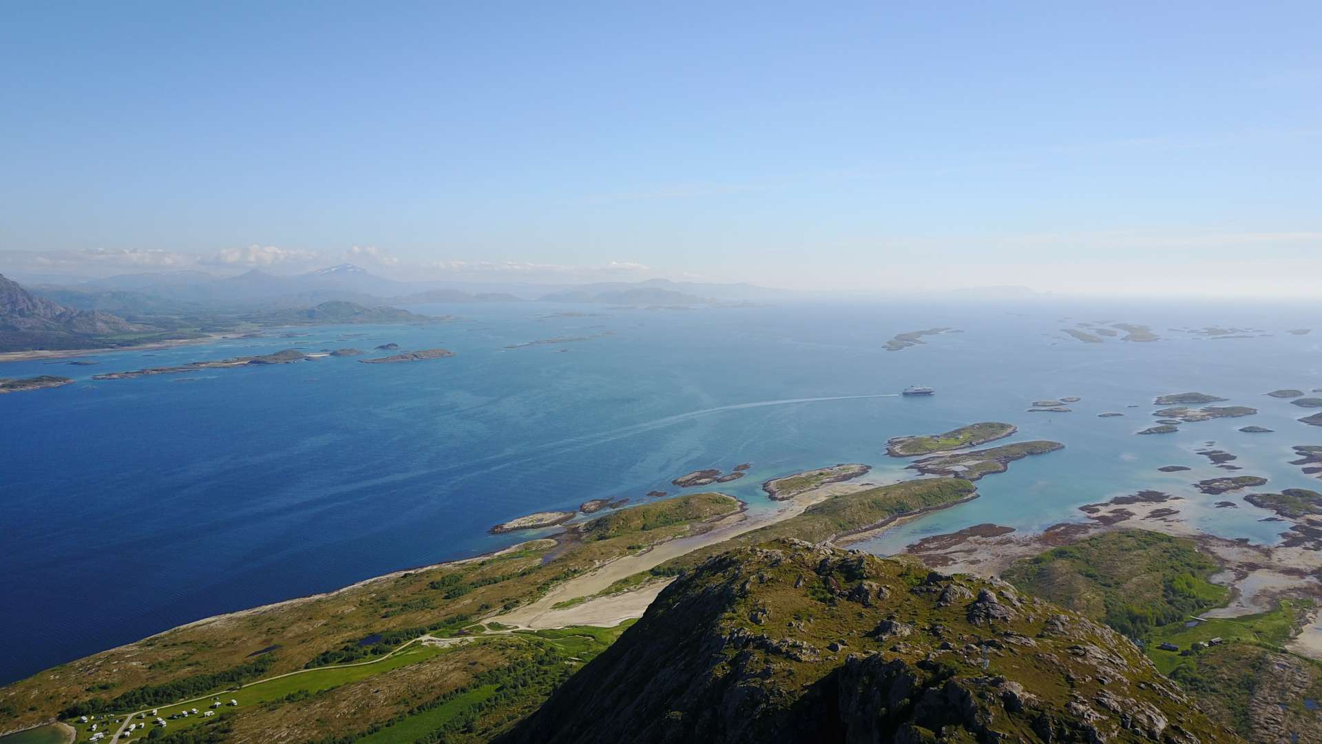
Then our campsite neighbors arrived: So, here's your hole. Have you taken a photo yet? We quickly distanced ourselves from the super-friendly people. Down by the bikes, we said goodbye, and the two rode back while I climbed up. Since the average Torghatten visitor was already retired, I was all alone during the ascent. At times it got quite steep, and I could feel my knees (both of them) very clearly. The view from the top was indescribably beautiful. In the northwest, there was a low sun, in front of it, lots of small rocky islands, and turquoise water in between. In the south, the roundish granite mountains rose, which became higher to the east and northeast and were partly still covered with snow. Blue water all around, green islands, and everything in incredibly clear air. The visibility was certainly more than 100km. I flew two batteries of the drone at the summit, and then it was time for the descent with even more painful knees and the 17km back to the campsite. The three of us conjured up another abundant meal (again spaghetti with sauce, but a very elaborate and delicious one), met our friendly Thuringians again ("you still have sun on your terrace, we don't"). And enjoyed the low sun as long as it didn't get too cold. By the way, the sun sets at 0:40 and rises again at 1:58. It's eleven o'clock now, and the sun is shining. Really strange.
Liostáil le Nuachtlitir
Freagra